 |
Harvey
Maps Scotland |
15
High Street, Upton upon Severn Worcs. WR8 0HJ Tel: 01684 593146 or 0800 085 40 80 (UK only) themapshop@btinternet.com |
| Link to Harvey Route Maps | |||||
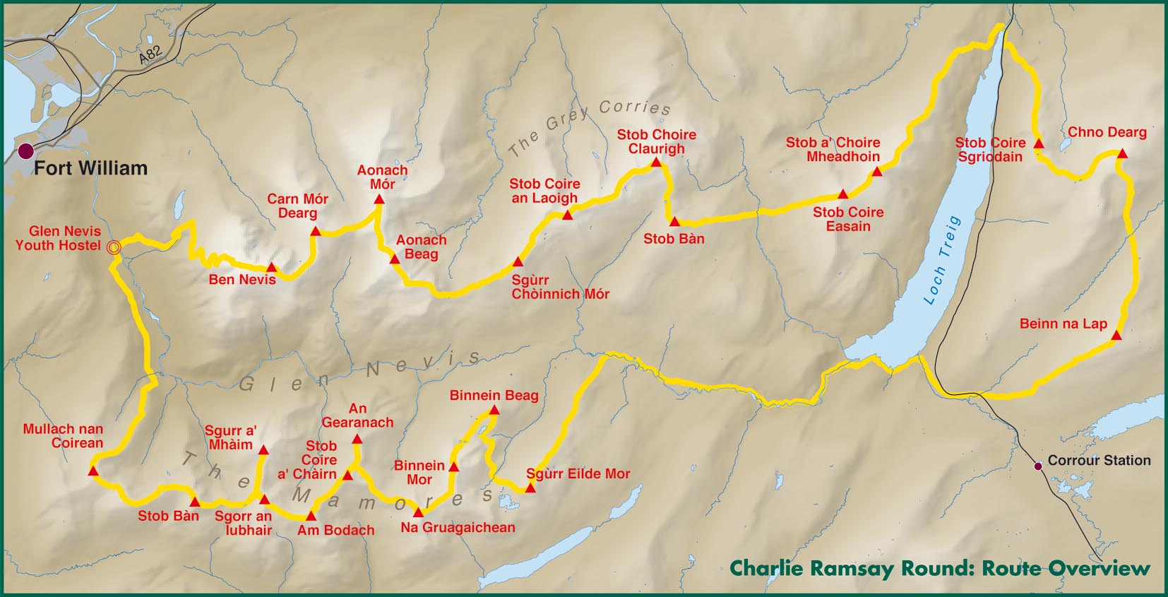
| £15.00 | Charlie Ramsay Round - New map in the 24 hour Challenge Series. Charlie Ramsay Round: In June 1964 Philip Tranter, son of the author Nigel Tranter, was the first to cover all of these mountains in a single trip, taking in the Mamores, the Grey Corries, the Aonachs, Carn Mor Dearg and Ben Nevis. Could Tranter's round be extended to 24 Munros within 24 hours? At 12 noon on Saturday 8th July 1978, Charlie Ramsay left Glen Nevis Youth Hostel, travelling anticlockwise, heading onto the Mamores. He returned to the youth hostel having completed the circuit in 23h 58m on Sunday 9th July with only 2 minutes to spare. The Charlie Ramsay Round was a reality. 24 Munros within 24 hours: The round's original benchmark.. This map joins the extremely successful HARVEY maps of the Bob Graham Round and the Paddy Buckley Round. Suggested route clearly marked, 100% Waterproof, Detailed, clear and easy to read, Light to carry, Printed on virtually indestructible paper, Ideal route planning tool, Can be used with GPS, History notes, useful advice and other information |
Order |
 |
||
| £ 8.50 | 1/40 000 | Affric Kintail Way - is a superb cross-country route for walkers, mountain bikers and horse riders stretching almost 44 miles from Drumnadrochit by Loch Ness to Morvich in Kintail by Loch Duich. The trail is in close proximity to the Great Glen at Drumnadrochit thus offering the traveller the opportunity of extending their journey. The Way has been created by linking a number of rights of way, forest trails and footpaths that have existed in some cases for centuries. | Order | ||
| £17.50 | 1/40 000 | Assynt
- British Mountain Map This map shows the spectacular sandstone peaks of Assynt at 1:40,000 scale on one sheet. Includes Quinag, Suilven, Stac Pollaidh, Cul Mor and Ben More Assynt. The map area includes 2 Munros, 9 Corbetts and 6 Grahams. |
Order | ||
| £17.50 | 1/40 000 | Ben Nevis - British Mountain Map | Order | Image | |
| £17.50 | 1/40 000 | Cairngorms & Lochnagar - British Mountain Map | Order | Image | |
| £17.50 | 1/40 000 | Knoydart & Kintail - British Mountain Map | Order | Image | |
| £17.50 | 1/40 000 | Schiehallion, Ben Lawers & Glen Lyon - British Mountain Map | Order | Image | |
| £17.50 | 1/40 000 | Southern Highlands - British Mountain Map | Order | Image | |
| £17.50 | 1/40 000 | Torridon & Fisherfield - British Mountain Map | Order | Image | |
| £15.50 | 1/40 000 | Loch Lomond & the Trossachs
National Park - Outdoor Atlas - New
concept in outdoor mappping: the whole of Scotland's first National Park
in one handy book.
|
Order | Image | |
| £15.50 | 1/25 000 | An Teallach and Fisherfield - XT25 Superwalker - An Teallach and Fisherfield covers a spectacular group of remote northerly Munros popular with walkers and climbers. The map area includes 8 Munros, 5 Corbetts and 2 Grahams. | Order | Image | |
| £15.50 | 1/25 000 | Arran - T25 - All Weather map inc. Arran Coastal Way | Order | Image | |
| £15.50 | 1/25 000 | Arrochar
Alps - Superwalker XT25 - Harvey Map Includes Beinn Ime, Ben Vorlich and the Cobbler (Ben Arthur). Detailed map for hillwalkers of the Western part of the Loch Lomond and Trossachs National Park at the popular scale of 1/25 000. Includes 5 Munros, 10 Corbetts and 13 Grahams |
Order | ||
| £15.50 | 1/25 000 | Ben Alder - XT25 Superwalker - Craig Meaghaidh and Corrour Station. Area around Ben Alder west of Dalwhinnie & A9 | Order | ||
| £15.50 | 1/25 000 | Ben Lawers - The Hills from Loch Tay to Glen Lyon. Includes Ben Lawers and the Tarmachan Ridge, with 15 'Munros' and 4 'Corbetts'. | Order | Image | |
| £15.50 | 1/25 000 | Ben Ledi Callander - Aberfoyle and Callander north to Balquhidder and Lochearnhead. Ben Vorlich and Stuc a'Chroin are the 2 'Munros', Ben Ledi one of the 3 'Corbetts'. Ben Venue, the Menteith Hills, Achray Forest, Loch Venacher, Strathyre and the Trossachs | Order | Image | |
| £15.50 | 1/25 000 | Ben Lomond & Loch Katrine - The hills stretching east from Loch Lomond over to Loch Ard and Trossachs, including the most southerly Munro - Ben Lomond. To the north the Corbetts above Inverlochlarig. The map covers all of Loch Katrine | Order | Image | |
| £15.50 | 1/25 000 | Ben Nevis - Fort William through Glen Nevis to Lock Treig. From the Grey Corries south to Kinlochleven. Ben Nevis, the Aonachs and the Mamores are among the 20 'Munros' and 4 'Corbetts'. Enlargement of Ben Nevis summit. | Order | Image | |
| £15.50 | 1/25 000 | Ben Venue - This map covers the area west of Callander in the south eastern part of the National Park, including Ben Venue, Loch Ard Forest and The Trossachs. | Order | Image | |
| £15.50 | 1/25 000 | Cairn Gorm - XT25 - From Coylumbridge through the Lairig GlGhru to Glen Dee. The 'Munro' Monadh Mor is in the west with Glen Derry in the east. 12 'Munros' including 5 over 4000' (Cairn Gorm, Ben Macdui, Cairn Toul, Braeriach & Sgor an Lochain Uaine) and 1 'Corbett' | Order | Image | |
| £15.50 | 1/25 000 | Crieff
& Comrie, Doune & Dunblane - Superwalker XT25 - Harvey Map Map covers the Munro, Ben Chonzie, popular Glen Artney, as well as the Braes of Doune and Doune Castle, which has featured in various film and television shows, such as Monty Python, Outlander and Game of Thrones. Detailed map for hillwalkers at the popular 1/25 000 scale. Core paths (from the relevant Local Authorities) are shown. Includes 1 Munro, 2 Corbetts and 4 Grahams. |
Order | ||
| £15.50 | 1/25 000 | Fannichs:
Seana Bhraigh & Ben Wyvis - Superwalker XT25 - Harvey Map Detailed map for hillwalkers of the Fannichs ridge at the popular 1/25 000 scale. This is an area located to the south of Ullapool and to the west of Dingwall. Includes the munros, Sgurr Mor, Beinn Dearg and Seana Bhraigh. Includes an inset of the Munro, Ben Wyvis. Shows 17 Munros, 3 Corbetts and 3 Grahams |
Order | ||
| £15.50 | 1/25 000 | Galloway
Hill - Superwalker XT25 - Harvey Map The Galloway Hills form part of the Southern Uplands of Scotland. This map for hillwalkers covers Glen Trool and Loch Dee north to Loch Doon and Carrick Forest. It covers a large part of the popular Galloway Forest park. The Minnigaff Hills, Merrick, Corerine, the Dungeon Hills and many lochs make this area a delight to walk. Includes 3 Corbetts, 4 Grahams and 11 Donalds. |
Order | ||
| £15.50 | 1/25 000 | Glen Coe - Loch Leven south to Loch Etive via the Aonach Eagach, Buachaille Etive Mor, Three Sisters of Glen Coe, Bidean nam Bian. From Victoria Bridge north over the Black Mount and west to Ben Starav, one of 20 'Munros'. There are 6 'Corbetts'. | Order | Image | |
| £15.50 | 1/25 000 | Jura
- Superwalker XT25 - Harvey Map Shows the Paps of Jura and includes 1 Corbett and 2 Grahams. This detailed map for hillwalkers shows the whole of the Isle of Jura at the popular scale of 1/25 000. Jura's unusual raised beaches are well marked on the map. |
Order | ||
| £15.50 | 1/25 000 | Knoydart - The Knoydart Superwalker map covers this wild, remote and beautiful area at 1:25,000 scale. The map area includes 6 Munros, 7 Corbetts and 2 Grahams. | Order | Image | |
| £15.50 | 1/25 000 | Loch Lomond & The Troassachs - Superwalker XT25 - Harvey Map | Order | ||
| £15.50 | 1/25 000 | Lochnagar, Glenshee and Mt Keen - XT25 Superwalker - North of Sheet - South of Braemar, South of sheet - Spittal of Glenshee, East of sheet - Spittal of Glenmuick & Loch Muick, Mt Keen as inset | Order | ||
| £15.50 | 1/25 000 | Mull,
Iona, Ulva - Superwalker XT25 - Harvey Map 1/25 000 scale walking map of the mountains of Mull with a recreation map of the whole island on the reverse at 1/55 000. Map enlargement of Iona at 1/25 000 scale. Includes 1 Munro, 1 Corbett and 7 Grahams. |
Order | ||
| £15.50 | 1/25 000 | Ochil Hills - Superwalker - From Gleneagles and Auchterarder in the north and border by the A91 Hillfoots road in the south. Features Dumyat, Ben Cleuch and Blairdenon Hill, enlargements of Hillfoot glens, an enlargement of Abbey Craig (including the Wallace Monument) and Stirling University Campus | Order | Image | |
| £15.50 | 1/25 000 | Pentland Hills - From Edinburgh (City Bypass) south westwards to Dunsyre and Bleak Law. From the A702 in the east, through West Linton, to the west the A70 through Balerno. Caerketton and Allermuir Hills province panoramic views over Edinburgh and the Forth. | Order | Image | |
| £15.50 | 1/25 000 | Pitlochry,
Loch Tummel & Blair Atholl - Superwalker XT25 - Harvey Map Detailed map for hillwalkers of Pitlochry, Loch Tummel and Blair Atholl at the popular 1/25 000 scale. Includes Ben Vrackie, Beinn a'Ghlo and Pass of Killiecrankie. Shows Aberfeldy in the south, Pitlochry to the east and the hills north of Blair Atholl. Includes 5 Munros and 4 Corbetts. |
Order | ||
| £15.50 | 1/25 000 | Rum,
Eigg, Canna, Muck - Harvey Superwalker (XT25) Detailed map for hillwalkers of the Small Isles at the popular 1/25 000 scale. Information on Canna provided by the National Trust for Scotland. Includes scheduled ancient monuments. Includes 2 Corbetts & 1 Graham |
Order | ||
| £15.50 | 1/25 000 | Skye Storr & Trotternish - The Trotternish Ridge from Portree north including the Old Man of Storr and the Quiraing. | Order | Image | |
| £15.50 | 1/25 000 | Skye the Cuillin - From Glen Brittle and the unique Black Cuillin in the west to the Red Cuillin and Broadford in the east. From the Sligachan Hotel and the A87 to the dramatic Loch Coruisk tot he south. An enlargement of the Black Cuillin ridge at 1:12,500 scale is on the back of the map. Includes 12 'Munros' and 2 'Corbetts'. | Order | Image | |
| £11.50 | 1/25 000 | Suilven - Suilven covers a spectacular group of hills popular with walkers and climbers including Stac Pollaidh and Ben More Assynt. The map area includes Munros, Corbetts and Grahams. | Order | Image | |
| £15.50 | 1/25 000 | Torridon - Torridon & Kinlochewe in the south to the A832 in the north. Siloch, Beinn Eighe, Liathach and Beinn Alligin are covered by this sheet (enlargement of Liathach on back of map). Includes 7 'Munros' and 5 'Corbetts'. | Order | Image | |
| £15.50 | 1/25 000 | Trossachs North, Loch Lyon Crianlarich - XT25 Superwalker - North section, including Loch Lyon and Crianlarich. Ben Lui & Conoish Gold Mine | Order | ||
| £ 8.50 | 1/80 000 | Stirling, Forth Valley & the Trossachs -
XT80 - Cycling
map of Stirling, the Forth Valley and the Trossachs at 1:80,000 scale.
Map shows 16 graded cycle routes with detailed route descriptions on
reverse Includes enlargement of Stirling city centre |
Order | ||
| £ 6.50 | 1/12 500 | Ben Nevis Summit Map - This map for hillwalkers provides an enlargement of the summit of Ben Nevis at 1:12,500 scale. Size A3 (297 x 420mm). Laminated. Useful for detailed navigation in this complex area, particularly in poor conditions. Has a 100m grid for use with GPS or a romer. Includes the bearings for the escape route recommended by the Mountain Rescue | Order | ||
| £ 5.50 | 1/12 500 | Ben Aligin Summit Map - This map for hillwalkers provides an enlargement of the summit of Ben Alligin at 1:12 500 scale. Size A3 (297 x 420mm). Laminated. Useful for detailed navigation in this complex area, particularly in poor conditions. Has a 100m grid for use with GPS or a romer. | Order | ||
| £ 6.50 | 1/12 500 | Liathach Summit Map - This map for hillwalkers provides an enlargement of the summit of Liathach at 1:12 500 scale. Size A3 (297 x 420mm). Laminated. Useful for detailed navigation in this complex area, particularly in poor conditions. Has a 100m grid for use with GPS or a romer. | Order | ||
| £ 7.50 | Panorama Central Scotland - Large full colour panorama of the Highlands viewed from central Scotland. Includes on the reverse historical and tourist information, plus street maps. Size 700x840mm folded in stiff cover | Order | |||
 |
We
are now taking payments using |