 |
Harvey
Maps Wales |
15
High Street, Upton upon Severn Worcs. WR8 0HJ Tel: 01684 593146 or 0800 085 40 80 (UK only) themapshop@btinternet.com |
| Link to Harvey Route Maps | |||||
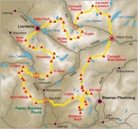
| £15.50 | Paddy Buckley
Round -
The ideal planning and navigation guide Detailed waterproof map including the suggested route to complete all 61.25 miles and 47 tops. The route was first completed by Wendy Dodds on 30 May 1982. Detailed HARVEY mapping at 1:40,000 scale. Clear and easy to read, Waterproof, Light to carry Can be used with GPS, Ideal route planning tool |
Order |
 |
||
| £16.50 | each | 1/40 000 | Wales Coast Path 1 - Chester to Caernarfon - Including Anglesey Coastal Path | Order | |
| £17.50 | each | 1/40 000 | Wales Coast Path 2 - Caernarfon to Cardigan - Including Llyn Peninsula | Order | |
| £17.50 | each | 1/40 000 | Wales Coast Path 3 - Cardigan to Llanelli - Including Pembrokeshire Coast Path | Order | |
| £16.50 | each | 1/40 000 | Wales Coast Path 4 - Llanelli to Chepstow - Including Gower Peninsula | Order | |
| £18.50 | 1/40 000 | Brecon Beacons - British Mountaineering Map | Order | Image | |
| £17.50 | 1/40 000 |
Snowdonia North - British Mountaineering Map Covers from Portmadog North, "The 1:40,000 scale used by British Mountain Maps is excellent for hill walking. These maps provide clear, detailed information." Sir Chris Bonnington. Snowdonia's key mountains on a single map. Printed on plastic - durable, tear-resistent and 100% waterproof. Colour shading for easy identification of hills and valleys. Less than half the weight of a laminated map. Detailed 1:15,000 enlargements of Snowdon and Tryfan. Geological map of Snowdonia supplied by the British Geological Survey. Mountain incident and first aid advice, tips on using your map and compass, useful local phone numbers and websites |
Order | Image | |
| £17.50 | 1/40 000 |
Snowdonia South - British Mountaineering Map Covers from Aberdyfi North to Llyn Trawsfynydd |
Order | Image | |
| £17.50 | 1/40 000 | Glyndwr's
Way - National Trail Map 217km (135 mile) long National Trail meandering through the open moorland, rolling farmland, woodland and forest of mid-Wales. The Way starts at Knighton and ends in Welshpool. It takes you to some of the finest landscape features in Wales including the tranquil Radnorshire Hills, the shores of the Clywedog Reservoir and heather clad Plynlimon. There are also spectacular views over Cadair Idris, Lake Vyrnwy, the Cambrian mountains and Y Golfa. The highest point on the route is Foel Fadian at 510m (1530ft). |
Order | ||
| £17.50 | 1/40 000 | Offa's Dyke Path - National Trail Map | Order | Image | |
| £17.50 | 1/40 000 | Pembrokeshire Coast
Path - National Trail Map A leap forward in technical excellence: Tough, durable and 100% waterproof. This map for walkers is virtually indestructible in normal use. Compact and light - the map itself weighs just 60gms - a third of the weight of a bulky laminated map. You can fold or refold it time and again, or stuff it in your back pocket and it won't fall to pieces. The map shows the entire route St Dogmaels to Amroth on one sheet. Pembrokeshire Coast Path covers nearly 200 miles of the most spectacular scenery in Britain. It was Wales' first long distance route and is one of the 15 premier UK National Trails. Information on finding accommodation, camping, food. Directions to the start of the route. Also Ranger Service contact numbers and enlargements of towns/villages showing facilities available and tips on weather and clothing Detailed mapping, full legend. 1:40,000 scale. National Grid - can be used with GPS. |
Order | Image | |
| £15.50 | 1/25 000 | Brecon Beacons East - XT25 Superwalker - Including Pen y Fan & Black Mountains | Order | ||
| £15.50 | 1/25 000 | Brecon Beacons West - XT25 Superwalker - Including Pen y Fan & Foel Fraith, Fan Fawr, Fan Gyhirych | Order | ||
| £15.50 | 1/25 000 | Snowdonia Central - XT25 Superwalker - Including Rhinog Fawr, Moelwyn Mawr, Llyn Traivsfynydd, Porthmadog, and Harlech | Order | ||
| £15.50 | 1/25 000 | Snowdonia South, Cadair Idris, Dolgellau - XT25 Superwalker - Including Cadair Idris, Tauren Hendre, Aran Fawddwy, Barmouth and Dolgellau | Order | ||
| £15.50 | 1/25 000 | Snowdonia North - XT25 Superwalker - Including The Glyders and Carnedds. All 3000ft mountains on one sheet | Order | ||