 |
Cassini
Maps Revised New Series |
15
High Street, Upton upon Severn Worcs. WR8 0HJ Tel: 01684 593146 or 0800 085 40 80 (UK only) themapshop@btinternet.com |
| Home | Great
Britain Maps & Guides |
European Maps & Guides |
Rest
of the World Maps & Guides |
Search |
First published between 1896 to 1904
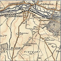 |
By the late 1890s, the Ordnance Survey had produced two complete series of maps of England & Wales but the increasingly rapid pace of change and development meant that revising them was now a never-ending task. The main cause of this change was the growth of the railways. From being little more than a good idea in 1830, the network covered over 18,000 miles by the end of the century, enabling the spread of goods, people and ideas and changing the character of every place it touched. The late 19th-century was without doubt the age of the railway, and the Revised New Series is the definitive record of its glory years. |
| Another,
quieter, technological revolution was also taking place at this time:
the development of colour printing. Information could now be
displayed in more subtle and varied ways, and at a reasonable
cost. The government, the military and, increasingly, the public
were demanding that the map-makers responded to this. After a new
survey in the early 1890s, the Revised New Series (in colour) was
published from 1896. This captured both the variety of the natural
landscape and the human influence of Britain's late-Victorian heyday in
delicate shades of sepia, blue and ochre.
The Revised New Series is an immaculate record of a vibrant society on the threshold of a still greater period of development and urbanisation. It records countless reminders of the past, many of which were about to be swept away for good. For local historians, this is the final record of your part of the country before the changes brought by the motor car. If your interest is genealogical, the series coincides with the 1901 Census, showing the landscape your ancestors inhabited. Whatever your reason for being interested in your area's past, prepared to be entranced by these maps - enlarged and combined to match the present-day OS Landrangers, they will reveal secrets of a familiar landscape you never knew existed |
|
| ORDER ONLINE |
| HOME | BACK TO CASSINI OVERVIEW | BACK
TO CASSINI CENTRED |
BACK TO CASSINI OLD SERIES |