 |
Austria |
15
High Street, Upton upon Severn Worcs. WR8 0HJ Tel: 01684 593146 or 0800 085 40 80 (UK only) themapshop@btinternet.com |
| Home | Great
Britain Maps & Guides |
European Maps & Guides |
Rest
of the World Maps & Guides |
Search |
| Official Government Maps - Index Sheets available on request for Map Series Marked:-*** | |||||
| £11.00 | each | 1/25 000 | Official Series - enlargements of the 1/50
000 information - mapping
sample When ordering please indicate whether you need the East or West sheet |
View Index East or West |
|
| £11.00 | each | 1/50 000 | Official Series - To order only | BUY | View Index East or West |
| Other Maps | |||||
| £ 6.99 | 1/400 000 | Michelin sheet 730 - covers Austria on one sheet | BUY | ||
| £12.50 | 1/300 000 | Freytag & Berndt - Austria | BUY | ||
| £ 9.95 | 1/1 336 500 | Ski Resort Map of the Alps by 2theAlps - Locates 640 Ski Resorts, with detailed info on 100. Indicates major road network and roads serving resorts. Alpine rail network and highlighting airports with linked stations | BUY | ||
| £12.50 | 1/500 000 | Alpine Countries (Austria, Germany, Liechtenstein, Switzerland, France, Italy & Slovenia) - Freytag & Berndt Road Map | BUY | ||
| £12.00 | 1/550 000 | Reise Know-How Map - Alps | BUY | ||
| £12.50 | 1/150 000 | Freytag & Berndt Map - Austria Lower | BUY | 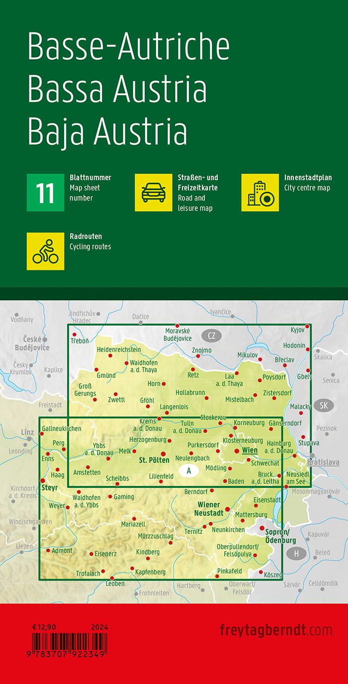 |
|
| £12.50 | 1/150 000 | Freytag & Berndt Map - Austria Upper | BUY | 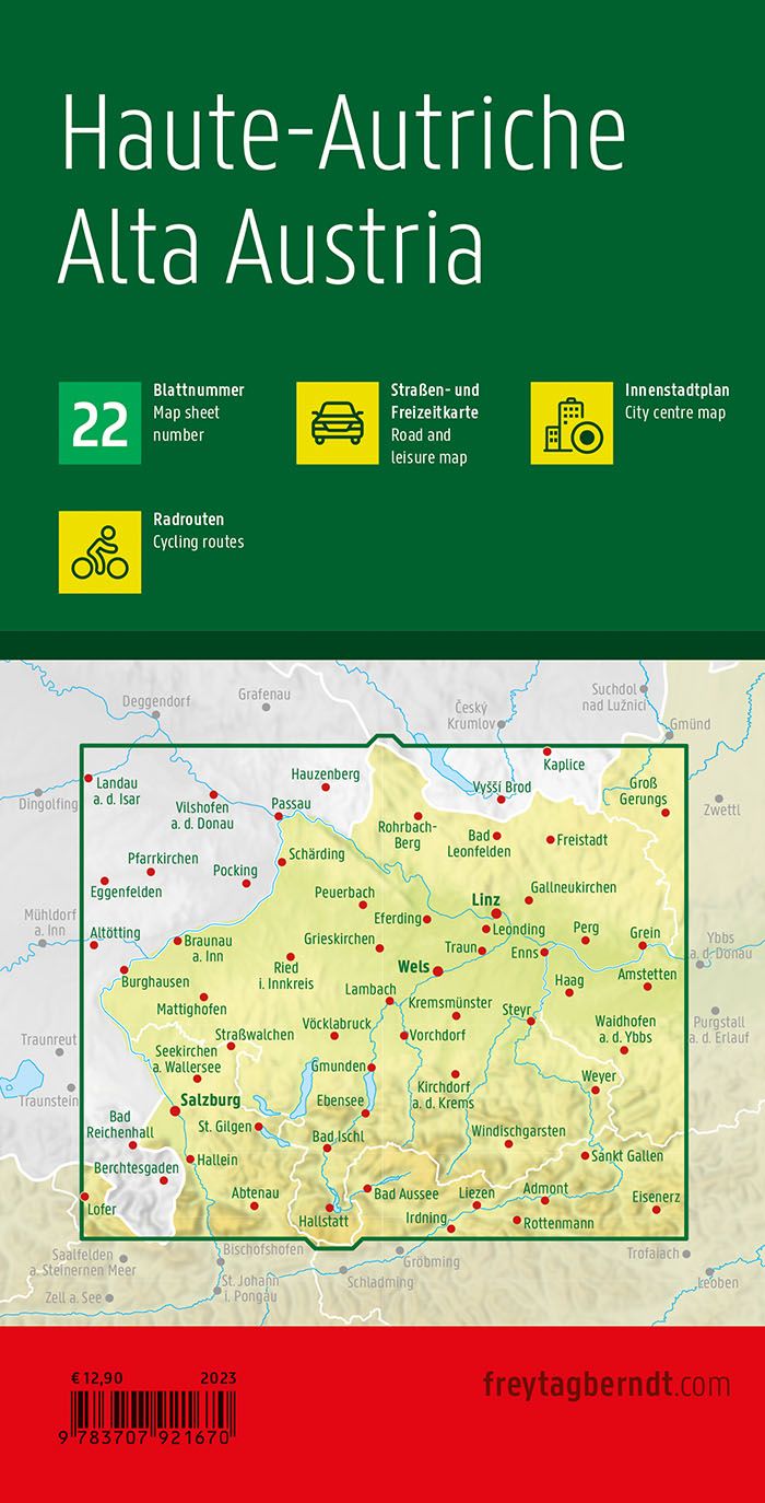 |
|
| £12.50 | 1/150 000 | Freytag & Berndt Map - Austria Tyrol | BUY | 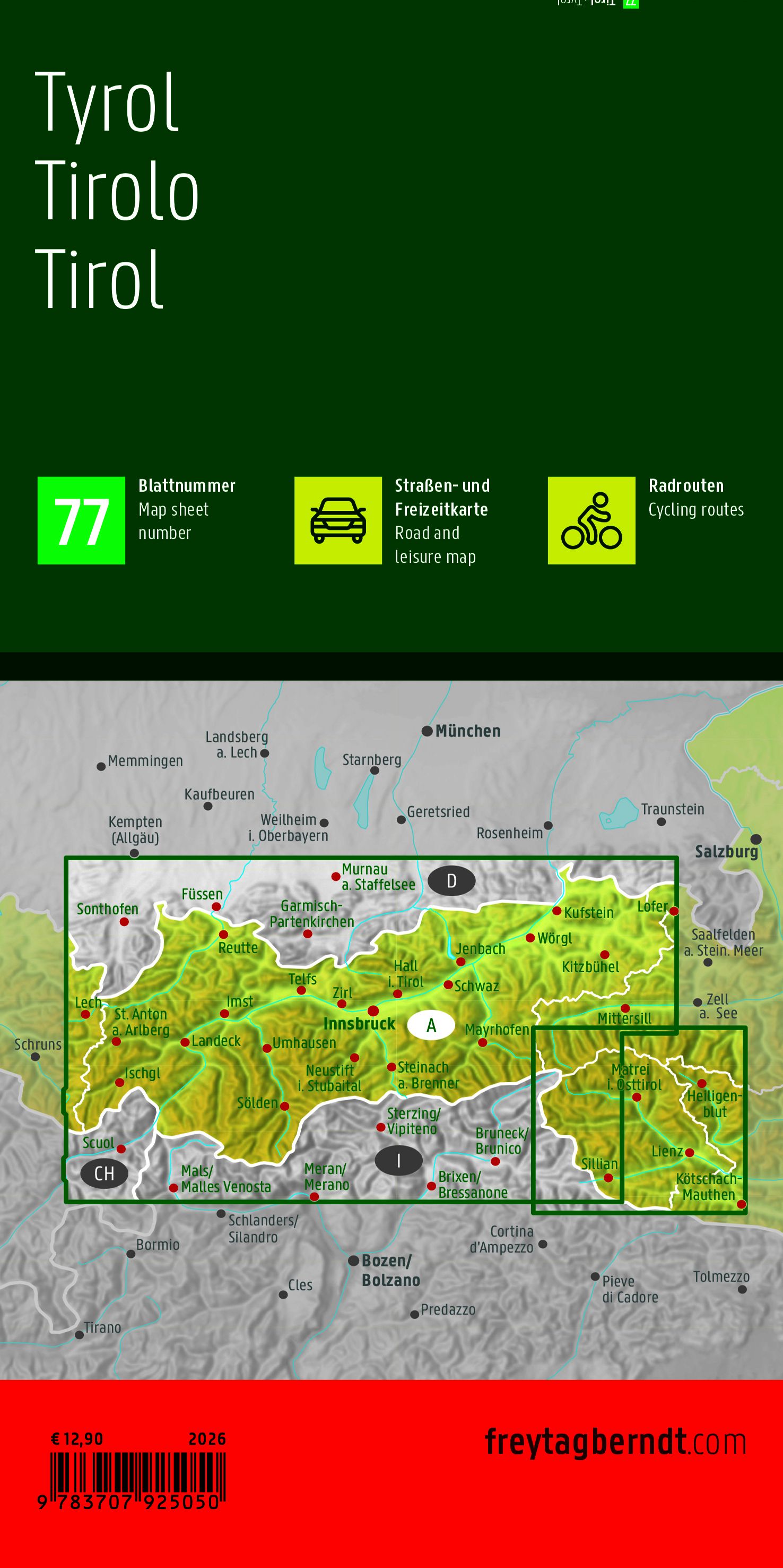 |
|
| £ 8.50 | 1/25 000 | Phone Map (Freytag
& Berndt) - Map No 245 - Kitzbuhel and surrounds For hiking & cycling (printed on waterproof, tearproof, ecological paper with free download) |
BUY | ||
| £10.50 | 1/50 000 | Phone Map (Freytag & Berndt) - Map No 164 - Regensburg and surrounds - For hiking & cycling (printed on waterproof, tearproof, ecological paper with fee download) | BUY | ||
| From £ 7.75 |
each | various | Kompass Wanderkarte - Hiking maps These dedicated hiking and cycling maps are clear, intuitive to read, and tear-proof and weather proof. They show the official path networks for hikers (red) and cyclists (green), including the signposts visible in nature (names, number, symbols). This includes long-distance hiking trails and other marked trails, mountain bike, ski, and snowshoeing trails where applicable. The paths are classified depending on their quality and bike parks, single trails, Nordic walking, theme trails etc. are identified. Valuable tourist content (brown) regarding cuisine, accommodation, sights, leisure, sport, and culture are clearly marked. Many maps come with a small active guide with suggested tours relevant to the region and ideas for leisure and outdoor pursuits, and some include 25k map insets for most popular areas. |
View Index & Order | |
| Mayr Maps - with touring, hiking & biking routes overlaid, printed on laminated, waterproof & rip-proof paper - (Note: This series is no longer available for us to order. Maps listed below are still in stock) - See list below | |||||
| £ 7.75 | 1/35 000 | 71 - Salzburger Saalachtal (Lofer, St Martin, Unken, Weibach) - Mayr Map | BUY | View Index |
|
| £11.75 | 1/25 000 | 405 - Tiroler Lechtal - Mayr 2 Map Set | BUY | ||
| £ 8.75 | 1/25 000 | 409 - Tannheimertal Tal, Reutte (Fussen, Pfronten, Bad Hindelang) - Mayr Map | BUY | ||
| £ 8.75 | 1/25 000 | 460 - Kaiserwinkl (Walchsee, Kossen, Schwendt, Rettenschoss) - Mayr Map | BUY | ||
| £ 7.75 | 1/25 000 | 461 - Pillerseetal (Hochfilzen, Fieberbrunn, St Jakob, Waidring) - Mayr Map | BUY | ||
| £11.75 | 1/25 000 | 480 - Hochpustertal - Mayr 2 Map Set | BUY | ||
| £ 7.75 | 1/25 000 | 540 - Ausseerland, Totes Gebirge (Altaussee, Bad Aussee, Grandlss, Obertraun, Tauplitz) - Mayr Map Coverage | BUY | ||
| From £11.50 |
each | 1/25 000 | Tabacco - mostly available for the Dolomites areas but now extending into part of Austria (Based on IGM Official Mapping) | BUY | View Index |
| £12.50 | each | 1/50 000 | Freytag & Berndt Wanderkarte walking maps | BUY | View Index - WEST View Index - EAST |
| £12.50 | each | 1/35 000 | Freytag & Berndt Wanderkarte Walking Maps - this series is now out of print but some are still in stock at larger scale that the above, see list of available titles below: | ||
| WK 5011 - Wienerwald (NP Fohrenberge, Baden, Helenental, Lainzer Tiergarten) | BUY | ||||
| WK 5031 - Mariazell, Otscher, Josefsberg, Annaberg, Erlaufsee | BUY | ||||
| WK 5041 - Hochschwab (Aflenz, Wildalpen, Salzatal) | BUY | ||||
| WK 5121 - Grobvenediger, NP Hohe Tauern, Krimml, Mittersill | BUY | ||||
| WK 5131 - Teichalm, Schockl, Raabklamm, Weiz, Birkfeld | BUY | ||||
| WK 5181 - Grobglockner, Heiligenblut, Sonnblick, Schobergruppe, Oberes Molltal | BUY | ||||
| WK 5233 - Worthersee, Ossiacher See, Faaker See, Keutschacher See | BUY | ||||
| WK 5262 - Bohmerwald (Hochficht, Rohrbach, Moldau Stausee) | BUY | ||||
| WK 5364 - Hinterer Bregenzerwald (Kleines Walsertal, Damuls) | BUY | ||||
| WK 5501 - NP Kalkalpen, Pyhrn-Priel Region, Hinterstoder, Windischgarsten | BUY | ||||
| WK 5502 - Semmering, Gloggnitz, Wechsel, Friedberg | BUY | ||||
| WK 5503 - Traunsee, Gmunden, Almtal, Hollengebirge, Traunstein | BUY | ||||
| £12.50 | 1/50 000 | WK D10 - Bodensee | BUY | ||
| From £ 7.75 |
each | various | Kompass Cycle Maps - View Indexes | BUY | |
| £12.50 | 1/125 000 | Freytag & Berndt Cycling Map (Strip Map) - Vienna & surroundings (Map Ref RF2) | BUY | ||
| AV (Alpenverein) Mountain Series - many available in either walking or ski editions, see below - Some of these maps are at 1/25 000 and some are at 1/50 000, we will be happy to confirm the scale if you can let us know the sheet required | |||||
| £10.95 | each | AV (Alpenverein) Ski Editions - Sample | BUY | View Index |
|
| £10.95 | each | AV (Alpenverein) Walking Editions - Sample | BUY | View Index |
|
| £10.95 | each | AV (Alpenverein) Walking & Ski Combined | BUY | View Index |
|
| Road Atlases | |||||
| £18.95 | 1/150 000 | Austria - Freytag & Berndt Road Atlas - (Spiral Bound) | BUY | ||
| £14.99 | various | Michelin Road Atlas -
Germany (1/300 000), Switzerland (1/400 000), Benelux (1/400 000), Austria
(1/400 000) & Czech Republic (1/600 000) Temporarily out of print awaiting a new edition, no date |
BUY | ||
| Street Plans - Please note that publishers and prices can vary depending on availability | |||||
| £ 4.95 | 1/10 000 | Bregenz - ADAC Street Plan | BUY | ||
| £ 6.25 | 1/15 000 | Graz - ADAC Street Plan | BUY | ||
| £ 5.50 | 1/11 000 | Innsbruck (with city guide and panorama) - Mayr City Map | BUY | ||
| £12.50 | 1/7 500 & 1/15 000 | Innsbruck - Freytag & Berndt Street Plan | BUY | ||
| £ 6.25 | 1/15 000 | Klagenfurt - ADAC Street Plan | BUY | ||
| £ 6.25 | 1/17 500 | Linz - ADAC Street Plan | BUY | ||
| £ 8.00 | 1/10 000 | Salzburg - Freytag & Berndt Tourist Map | BUY | ||
| £ 5.75 | 1/15 000 | Salzburg - ADAC Tourist Street Plan | BUY | ||
| £12.50 | 1/25 000 | Vienna - Freytag & Berndt Street Plan | BUY | ||
| £11.50 | 1/15 000 | Vienna (Wien) - Includes map of NE Austria at 1:450k, plus City Centre at 1:10k. - ExpressMap | BUY | ||
| £12.50 | 1/20 000 | Villach - Freytag & Berndt Street Plan | BUY | ||
| Guides - Other publishers are available and can be ordered on request | |||||
| £16.99 | AUSTRIA - Lonely Planet Guide | BUY | |||
| £14.99 | Austria - Eyewitness Guide | BUY | |||
| £ 7.99 | Salzburg - Mini Rough Guide - New Title due Dec 24 | BUY | |||
| £ 7.99 | Vienna - Marco Polo Pocket Guide (including touring app) | BUY | |||
| £ 7.99 | Vienna - Mini Rough Guide A convenient, pocket-sized quick-reference companion to discovering what to do, where to stay, eat and drink, and how to get around, including top attractions and hidden gems not to miss, itinerary suggestions and some insights into the landscape, history, and culture of Vienna. Covers Innere Stadt, the Hofburg, Ringstrasse and it Museums, Outside the Ring, Schonbrunn, Acorss the Danube, Viennas's suburbs, the Wienerewald, the Danube Valley to the east. A perfect-on-the-move companion, especially for shorther trips. |
BUY | |||
| £ 8.99 | Vienna - Lonely Planet Pocket Guide | BUY | |||
| £ 9.99 | Vienna - Eyewitness Top 10 Guide | BUY | |||
| Walking Guides - German language walking guides by Kompass, Rother, Esterbauer and Dumont are available to order. If interested please contact us with details of the area you are visiting | |||||
| £18.95 | Walking in Austria -
Cicerone Press A comprehensive new guide on walking in Austria by Kev Reynolds with 102 routes described, suitable for a wide range of abilities and some classic hut-to-hut tours. Set out in ten sections by district across the Eastern Alps, this book includes full information on public transport, accommodation, gear required and safety issues, full details of 135 mountain huts and a German–English glossary. |
BUY | |||
| £32.95 | The 4000m Peaks of the Alps - Normal & Classic Routes - New Edition Due For Release. Available to Pre-Order | BUY | |||
| £14.95 | 100 Hut Walks in the Alps - Cicerone Press 100 day walks to suit alpine walkers of all abilities, with suggestions for some hut-to-hut overnight tours, in the Alps of France, Switzerland, Italy, Austria and Slovenia. Each walk and mountain hut has been specially selected to showcase the amazing diversity of this iconic mountain chain. With clear route descriptions, helpful map extracts and information on recommended maps for each walk, and practical information on walking in this region and staying in mountain huts. |
BUY | |||
| £22.50 | Walking in the ALPS (Kev Reynolds) Paperback - Cicerone Press - To Order Only | BUY | |||
| £17.95 | Trekking in the
Alps (Kev Reynolds) - Cicerone Press Guide 20 classic routes - Mont Blanc, Matterhorn, Monte Rosa, Walkers Haute Route, Jungfrau, Vanoise, Dolomites AV1 & AV2, GR5, Eastern Alps E5, Italian Alps GTA, Julian Alps, Alpine Pass Route, Oisans, Queyras, Mont Ruan, Stubai & Zillertal High Routes, Gran paradiso AV2 & Ratikon Hohenweg |
BUY | |||
| £18.95 | Trekking
Austria's Adlerweg - The Eagle's Way across the Austrian Tyrol - Cicerone Press
- Temporarily unavailable - New edition due July 23 An essential guidebook for anyone walking the Adlerweg, or Eagle's Way across the Austrian Tyrol. The 300km waymarked route from St Johann to St Anton follows established mountain and valley tracks. 6 low-level alternative stages and a challenging 8 stage variant are included, with suggestions for a 15 day and 21 day itinerary. |
BUY | |||
| £14.99 | Alpe Adria -
(From the Alps to the Adriatic) - Bradt Guide
- To Order Only The first and only English-language guide to this epic 750km hiking route through the mountains of Austria, Slovenia, And Italy , from the Grossglockner in Austria to Muggia near Trieste on the Adriatic coast. Includes detailed maps and route descriptions for all 43 stages with clear breakdown of time, distance and ascent, and information on accommodation, public transport, culture, wildlife etc |
BUY | |||
| £15.00 | Trekking in
Austrias Hohe Tauern - Cicerone Press Guide A guide to trekking in the Hohe Tauern in Austria’s Eastern Alps, a World Conservation Area, through Tirol, Salzburg and Karnten provinces. Describes four hut-to-hut treks, of different levels of difficulty, in the Gross Glockner, Reichen and Venediger mountain groups, and a fifth tour of the whole region and includes a comprehensive hut directory |
BUY | |||
| £14.95 | Innsbruck
Mountain Adventures - Cicerone Press Guide Day walks, Trail running, Via Ferratas, Mountain biking & family days out |
BUY | |||
| £15.95 | The Karnischer
Hohenweg - Carnic Peace Trail (Austria & Italy) - Cicerone Press
Guide English-language guidebook to the Karnischer Höhenweg, a 170km waymarked hut-to-hut trek along the border between Italy and Austria. Also known as the Carnic Peace Trail, it runs west to east along the Ridge of the Carnic Alps, the site of the WW1 front line. With information on planning your trip, accommodation and the history of the area. |
BUY | |||
| £17.95 | Walking in the
Salzkammergut - Cicerone Press Guide Guidebook describing 30 day walks among the lakes and mountains of Austria's Salzkammergut. Easily accessible from Salzburg, the area is sometimes described as the Austrian Lake District. Routes range from easy lakeside strolls and walks to local points of interest to more strenuous through-routes and ascents of the neighbouring peaks. |
BUY | |||
| £12.95 | SILVRETTA ALPS - Mountains & Landscapes, for Walking & Climbing - West Col (Ed. 2005) | BUY | |||
| £14.95 | Trekking in the Stubai
Alps - Stubai Rucksack Route & Glacier Tour - Cicerone Press Guide Trekking guide to two multi-day hut-to-hut tours in the stunningly scenic Austrian Tyrol, Europe, south of Innsbruck - the Stubai Rucksack Route (or Höhen Weg) and the more challenging Stubai Glacier Tour, which involves glacier crossing. Either tour can be completed in 8-10 days. Includes a comprehensive hut directory |
BUY | |||
| £12.99 | Vienna and Vienna Woods (50 walks) - Rother Walking Guide | BUY | |||
| £18.95 | Trekking in Austria's Zillertal Alps (The Zillertal Rucksack Route, South Tyrol Tour, Peter Habeler and Olperer Runde Tours) - Cicerone Press Guide | BUY | |||
| £ 9.99 | Around the Zugspitze - Rother Guide | BUY | |||
| Cycling Guides | |||||
| £ 9.00 | Salzkammergut Cycle Map - 1/75 000 - Esterbauer Map (RK-A05) | BUY | |||
| £ 9.00 | Burgenland Cycle Map - Esterbauer Bikeline Map | BUY | |||
| £17.95 | The Danube Cycleway Volume 1 - Cicerone Press Guide The first in a two-volume set, this guidebook describes cycling the first 1271km of the Danube river from its source in the Black Forest to Budapest, passing through Germany, Austria, Slovakia and Hungary. Suitable for all levels of cyclist, the route visits the great cities of Vienna and Bratislava before arriving in the Hungarian capital |
BUY | |||
| £17.95 | The Danube Cycleway Volume 2 - Cicerone Press Guide Cycling guidebook to the Danube Cycleway exploring the route from Budapest to the Black Sea, the more adventurous second part of the Danube, suitable for most abilities and bike types. The river route starts in Hungary and continues into Serbia and Bulgaria before ending at Constanta in Romania. The Danube Cycleway is also part of EuroVelo 6 (EV6). |
BUY | |||
| £17.50 | Danube Bike Trail Vol 2 - Passau to Vienna - (English edition with GPS, tracks, local maps & height profiles) - Esterbauer Cycle Guides | BUY | |||
| £17.50 | Danube Bike Trail Vol 3 - Vienna to Budapest - (English edition with GPS, tracks, local maps & height profiles) - Esterbauer Cycle Guides | BUY | |||
| £17.50 | Etsch-Radweg, Landeck to Verona (1/75 000) - Esterbauer Bikeline Guide | BUY | |||
| £17.50 | Mozart Bike Trail - Germany-Austria - Through the Salzburger Land, Berchtesgadener Land and Chiemgau - Esterbauer English guide | BUY | |||
| £17.50 | Tauern Cycle Path (Thru Austria & North to Passau - Salzach, Saalach & Inn Rivers) - Esterbauer English Guide | BUY | |||
| £17.50 | Via Claudia Augusta (Danube to Venice/Verona) - German Text - Esterbauer Cycle Guide | BUY | |||
| £ 9.00 | Vorarlberg 1/100 000 Map - Cycle Tours - Esterbauer | BUY | |||
| Climbing Guides | |||||
| £15.50 | STUBAI ALPS. (& South Tirol) - West Col (Ed. 2005)- To order only | BUY | |||