 |
Cassini
Maps Popular Edition |
15
High Street, Upton upon Severn Worcs. WR8 0HJ Tel: 01684 593146 or 0800 085 40 80 (UK only) themapshop@btinternet.com |
| Home | Great
Britain Maps & Guides |
European Maps & Guides |
Rest
of the World Maps & Guides |
Search |
First published between 1919 to 1926
 |
The original Ordnance Survey Popular Edition series was conceived
before, but published just after, the First World War. This was
the first of Ordnance Survey's series to be conceived from the outset as
a mass-market product, and the first to be produced in full
colour. The new technology was put to the test in catering of a
wholly new market.
If the railways were the transport revolution of the 19th century, the motor car was certainly that of the 20th. The new mapping series had to reflect this. For the first time the graduations of the road network were described, with each route being coloured according to its suitability or otherwise for motor traffic. Twenty times more vehicles were registered in the UK in 1929 compared to 20 years earlier, and many of those who could not afford (or did not dare) to use a car cycled instead. |
| Increased
leisure time and rising prosperity fuelled a demand for travel. As
a result, accurate, relevant and up to date maps were needed. The
Popular Edition provided them.
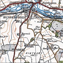
These Popular Edition maps show England & Wales on the threshold of great change. The roads ere threatening the railways, the suburbs were drawing people from the inner cities. Beyond the built-up areas, villages were turning into small towns, often with nearby parks and woods for recreation, while golf courses were in some areas starting to outnumber farms. Although there was still much open countryside containing many reminders of its past, England & Wales was increasingly dominated by the large urban areas and the roads that connected them. High ground was now represented by contours rather than artistic hachuring; more accurate, less intrusive and more relevant to a society that was now less reliant on travel by horse and cart or on foot. This fascinating map captures the point at which the motor car began to define not only the landscape but also the way in which map-makers represented it. |
|
| ORDER ONLINE |
| HOME | BACK TO CASSINI OVERVIEW | BACK
TO CASSINI CENTRED |
BACK TO CASSINI OLD SERIES |