 |
Harvey
Maps England & Isle of Man |
15
High Street, Upton upon Severn Worcs. WR8 0HJ Tel: 01684 593146 or 0800 085 40 80 (UK only) themapshop@btinternet.com |
| England
& Isle of Man |
Wales | Scotland | Ireland | Route Maps | CD-Roms |
| £10.50 | 1/12 500 | Malvern Hills - Waterproof map for the whole of the ridge from North Malvern to Whiteleaved Oak, including the Herefordshire and Worcestershire Beacons - For walkers, cyclists & horse riders | Order | Image |
| £15.50 | 1/30 000 | Isle of Man - All weather, strong durable map for walkers covering the whole island | Order | |
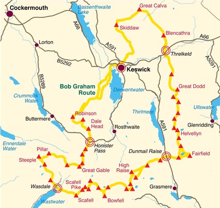
| £15.00 | 1/40 000 | Bob Graham Round - The historic 72 mile route completed by Bob Graham in 1932 is now a popular challenge. This new map is your essential guide, with recommended route and changeover points. Detailed, clear and easy to read HARVEY mapping Guide to the route by Jon Broxap, Waterproof, Light to carry, Can be used with GPS, Ideal for navigation on the fell and also an excellent planning tool Map size 486x700mm folded to pocket size 243x116mm consists of 4 sections, each providing a strip of map to cover the route and access points. The 1:40,000 map scale gives you a fully detailed map that is a handy size and minimum weight. Printed on robust, latex impregnated paper |
Order |
 |
| £15.00 | 1/40 000 | The Gerry
Charnley Round (Lakeland Fells) - The Gerry Charnley Round is a 38 mile clover leaf challenge originally devised in 1984 to celebrate the late Gerry Charnley. This map is your essential guide. Published by Harvey in conjunction with South Ribble Orienteering club as part of its 50th Anniversary celebrations. Detailed HARVEY mapping at 1:40,000 scale. Clear and easy to read. Waterproof. Light to carry. Can be used with GPS. Ideal route planning tool |
Order | |
| £17.50 | 1/40 000 | British Mountain Map -
Dartmoor XT40 The whole of Dartmoor on one map. Made in cooperation with the British Mountaineering Council. Printed on polyethylene - durable, tear-proof and 100% waterproof, Colour shading for easy identification of hills and valleys, Less than half the weight of a laminated map. Geological map of the area specially designed by the British Geological Survey. Mountain incident and first aid advice, Tips on using your map and compass. Useful local phone numbers and websites |
Order | View Area |
| £17.50 | 1/40 000 | British
Mountain Maps - Lake District The Lake District's famous mountains and fells on a single map. Printed on plastic - durable, tear-resistent and 100% waterproof. Colour shading for easy identification of hills and valleys. Detailed crag information for climbers and less than half the weight of a laminated map. Detailed 1:20,000 enlargements of Scafell, Gable, Bowfell, Langdale Pikes and Pillar, geological map of the Lake District. Mountain incident and first aid advice, tips on using your map and compass, useful local phone numbers and websites. |
Order | Cover Image |
| £17.50 | 1/40 000 | British Mountain Maps - White Peak | Order | View area |
| £17.50 | 1/40 000 | British Mountain Maps - Dark Peak - Harvey Map | Order | |
| £17.50 | 1/40 000 | British Mountain Maps -
Yorkshire Dales The Yorkshire Dales covers a huge area: over 600 square miles on a single map |
Order | View area |
| £11.50 | 1/40 000 | Lake District North - Harveys Ultramap XT40 - All weather map for runners & walkers | Order | |
| £11.50 | 1/40 000 | Lake District West - Harveys Ultramap XT40 - All weather map for runners & walkers | Order | |
| £11.50 | 1/40 000 | Lake District East - Harveys Ultramap XT40 - All weather map for runners & walkers | Order | |
| £11.50 | 1/40 000 | Lake District South East - Harveys Ultramap XT40 - All weather map for runners & walkers | Order | |
| £11.50 | 1/40 000 | Snowdonia Central - Harveys Ultramap XT40 - All weather map for runners & walkers | Order | |
| £11.50 | 1/40 000 | Peak District Central - Harveys Ultramap XT40 - All weather map for runners & walkers | Order | |
| £11.50 | 1/40 000 | Peak District North - Harveys Ultramap XT40 - All weather map for runners & walkers | Order | |
| £11.50 | 1/40 000 | Brecon Beacons West - Harveys Ultramap XT40 - All weather map for runners & walkers | Order | |
| £11.50 | 1/40 000 | Brecon Beacons East - Harveys Ultramap XT40 - All weather map for runners & walkers | Order | |
| £15.50 | 1/25 000 | Lake District North - The Northern Fells - Skiddaw, Blencathra, Great Calva, Keswick, Derwentwater | Order | Image |
| £15.50 | 1/25 000 | Lake District West - The Western Fells - Everything west of the Kendal-Keswick road, Scafell, Langdale, Hard Knott & Wrynose Passes, Ennerdale, Wastwater & Coniston Water | Order | |
| £15.50 | 1/25 000 | Lake Distict East - The Eastern Fells - Everything east of the Kendal Keswick road, Helvellyn, High Street, Kirkstone pass, Ullswater, Haweswater & Kentmere | Order | |
| £15.50 | 1/25 000 | Lake District South East - Kendal, Windermere, Ambleside, Grizedale Forest & Coniston Water | Order | |
| £11.95 | 1/25 000 | Howgill Fells - Eastern Cumbria from Tebay and Ravenstonedale to Dent and Barbon in the south. Includes the Calf, Wild Boar and Baugh Fells | Order | Image |
| £15.50 | 1/25 000 | Peak District - North - Shows the Dark Peak from the Snake Pass north to Marsden. Includes Bleaklow, Black Hill and Derwent Reservoir. | Order | |
| £15.50 | 1/25 000 | Peak Distrct - Central - Shows the heart of the Peak District National Park. Includes Edale, Kinder Scout, the Gritstone Edges and the Ladybower Reservoir. | Order | |
| £15.50 | 1/25 000 | Peak District - South - Shows the White Peak from Buxton to Matlock. Includes Leek, the Roaches and Dovedale. | Order | |
| £11.50 | 1/25 000 | Yorkshire Dales Bentham - Coverage starts at Barbon and Kirkby Lonsdale in the north and extends south through Ingleton and Austwick in the east and Gressingham in the west. High and Low Bentham lie in the middle of the map | Order | Image |
| £15.50 | 1/25 000 | Yorkshire Dales NE - XT25 Superwalker - Including Swaledale, Wharfedale, Wensleydale, Nidderdale | Order | |
| £15.50 | 1/25 000 | Yorkshire Dales NW - XT25 Superwalker - Including Howgill Fells, plus Calf, Cautley Crag, Wildboor Fell | Order | |
| £15.50 | 1/25 000 | Yorkshire Dales SE - XT25 Superwalker - Including Pen Y Ghent, Malham Grove, Wharfedale, Nidderdale | Order | |
| £15.50 | 1/25 000 | Yorkshire Dales SW - Three Peak Map - This map for hillwalkers includes Pen-y-Ghent, Whernside and Ingleborough | Order | Image |
| £15.50 | 1/40 000 | Lake District - Outdoor Atlas - the whole of the Lake District National Park in one handy volume. Spiral bound, waterproof, showing public footpaths & bridleways. Can be used with GPS | Order | Image |
| £15.50 | 1/40 000 | Yorkshire Dales - Outdoor Atlas - the whole of the Dales in one handy volume. Spiral bound, waterproof, showing public footpaths & bridleways. Can be used with GPS | Order | Image |
| £10.50 | 1/25 000 | Cannock Chase - 1:25,000 scale map of this popular area in the West Midlands. Ideal for walking, mountain biking and other outdoor activities. | Order | |
| £ 6.50 | 1/12 500 | Helvellyn Summit Map - Now in new format: Tough. Light. Waterproof. Printed on polyethyene. Supplied folded in a plastic pocketThis map for hillwalkers provides an enlargement of the summit of Helvellyn at 1:12,500 scale. Size A3 (297x420mm). Useful for detailed navigation in this complex area, particularly in poor conditions. Has a 100m grid for use with GPS or a romer. | Order | |
| £13.50 | Forest of
Bowland - This
map is 2 in 1: on one side is a walking map; on the other a map suitable
for cyclists and horseriders "The Forest of Bowland has a lot to offer walkers, horseriders and cyclists, and this practical map will help you to explore this beautiful part of England. The 1:25,000 scale walkers' map gives, for the first time, detailed information on how to enjoy the Access Land on the high fells of Bowland and all-ability routes in the lowlands, while the 1:55,000 scale maps shows the whole of the AONB in one map - perfect for planning longer distance walks and rides" Forest of Bowland Area of Outstanding Natural Beauty |
Order | Image | |
| £15.50 | 1/25 000 | Cheviot Hills XT25 Superwalker - Including Cheviot, Newton Tors, Kirknewton. Including north section of Pennine Way. For Hillwalkers and Cyclists | Order | |
| £15.50 | 1/25 000 | Dartmoor North XT25 Superwalker - Famous tors inc. Haytor Rocks, Yes, High Willhays. Archaeological Sites | Order | |
| £15.50 | 1/25 000 | Dartmoor South XT25 Superwalker - Famous tors inc. Great Staple and Ugborough Beacon. Archaeological Sites | Order | |
| £ 7.50 | 1/40 000 | Dales North - Detailed map for walking. GPS compatible. Rights of Way. Includes graded off-road cycle routes. Large area on a compact sheet. Yorkshire Dales North covers Swaledale and Wensleydale, including Keld, Hawes, Aysgarth and Leyburn. | Order | Image |
| £15.95 | 1/60 000 & 1/40 000 |
Dartmoor
for Cyclists - 2
maps in one: one side mountain biking the other side for cycle touring Tried and tested cycle routes, Side 1 is a detailed map of Dartmoor showing graded mountain bike routes. Covers the whole of the National Park. Scale 1:40,000 Side 2 for touring cycling shows the whole area from Exeter to Plymouth at 1:60,000 scale with recommended cycle-friendly routes shown. All paths and tracks where cyclists have a legal or permitted right to ride are shown. Routes have been graded and colour-coded by cyclists so that you can easily identify the paths that will suit your ability and mood Produced in cooperation with the National Park Authority. Includes cycling in the Tamar Valley and Haldon Forest Park |
Order | Image |
| £ 7.50 | 1/100 000 | Yorkshire
Dales Cycle Way - The entire cycle route
on one sheet. The route is circular, starting and ending in Skipton, with
an alternative start/end in Ilkley. The cycle map includes a route
profile. Steep gradients are marked. Enlargements of towns are included. Also includes information on accommodation, cycle shops and cycle hire. Made in cooperation with the Yorkshire Dales National Park Authority and in consultation with the CTC |
Order | Image |
| £ 5.00 | various | Cycle rides in Yorkshire Dales - 8 cycle rides in the Yorkshire Dales varying in length from 11 to 23 miles. Includes detailed maps plus written route directions. Information on local points of interest and sites to visit. Telephone numbers of tourist information centres and other useful contacts. | Order | Image |
| £ 8.95 | 1/100 000 | Yorkshire Dales for Cyclists
- Cycle
map of the whole Yorkshire Dales and Nidderdale Area of Outstanding
Natural Beauty. Scale 1:100,000. Includes cycle repair, cycle hire, steep
gradients. Includes town plans of Richmond, Hawes, Leyburn, Pateley Bridge, Sedbergh. Kirkby Lonsdale, Ingleton, Settle, Skipton, Grassington |
Order | Image |
The Map Shop, Walking and road Maps, Kompass Maps, Michelin Maps, Online, UK, European and Worldwide.
Please contact us on
Freephone: 0800 085 40 80 (UK only)
or
Telephone: 01684 593146 (International: +44 1684 593146)
©The Map Shop - Website
created and maintained by The Map Shop, Upton upon Severn.
All prices correct at time of last update.